Where Is Tent Rocks National Monument? | Map And Best Guide
Where Is Tent Rocks National Monument? Discover its exact location in New Mexico, view maps, directions, hiking trails, visitor tips, and the best time to visit Kasha-Katuwe Tent Rocks National Monument for an unforgettable adventure. Kasha-Katuwe Tent Rocks National Monument sits between Santa Fe and Albuquerque, New Mexico.
If you are asking Where is Tent Rocks National Monument?, you are likely planning a trip through the high desert or mapping a Southwest road loop.
I have hiked these canyons and studied the geology on site, and this guide brings together clear directions, local context, and practical tips. Keep reading to learn exactly where it is, how to get there, what to expect, and how to plan a safe, respectful visit that honors the land and its stewards.

Where Is Tent Rocks National Monument? Location overview
Kasha-Katuwe Tent Rocks National Monument lies in Sandoval County on the Pajarito Plateau of north-central New Mexico. It sits on lands of the Cochiti Pueblo and is co-managed by the Bureau of Land Management. The monument is about 40 miles southwest of Santa Fe and about 55 miles north of Albuquerque by road.
When people search Where is Tent Rocks National Monument?, they want a simple visual. Picture the map of New Mexico’s I-25 corridor between Santa Fe and Albuquerque. Draw a line west toward Cochiti Lake. The monument sits just west of Cochiti Pueblo near the Jemez foothills.
How to get there from Albuquerque and Santa Fe
From Albuquerque, drive north toward Bernalillo and the I-25 corridor. Follow signs toward Cochiti Pueblo and Cochiti Lake via state routes NM 16 and NM 22. You will pass through Pueblo lands before turning onto the signed access road to the monument.
From Santa Fe, head south on I-25 and follow signs for Cochiti Pueblo and Cochiti Lake. Continue west on NM 16, then south on NM 22 to the signed turn for the monument. Drive times are usually 60 to 75 minutes from Albuquerque and 45 to 60 minutes from Santa Fe, depending on traffic and road work.
The question Where is Tent Rocks National Monument? also implies access. Roads may be gated during closures, special events, fire restrictions, or after storms. Always check current notices before you go.

Map, GPS, and boundaries
The main entrance and trailhead sit near 35.652° N, 106.408° W. These coordinates will place you near the day-use area and parking lot when open. Cell service can be spotty, and map apps may route you onto private or closed roads. Download offline maps and follow official roadside signs.
The monument’s boundaries adjoin Cochiti Pueblo and other protected areas. Drones, off-trail travel, and climbing on formations are restricted. When you ask Where is Tent Rocks National Monument?, know that “where” includes legal and cultural limits, not just a dot on the map.

History, geology, and why it matters
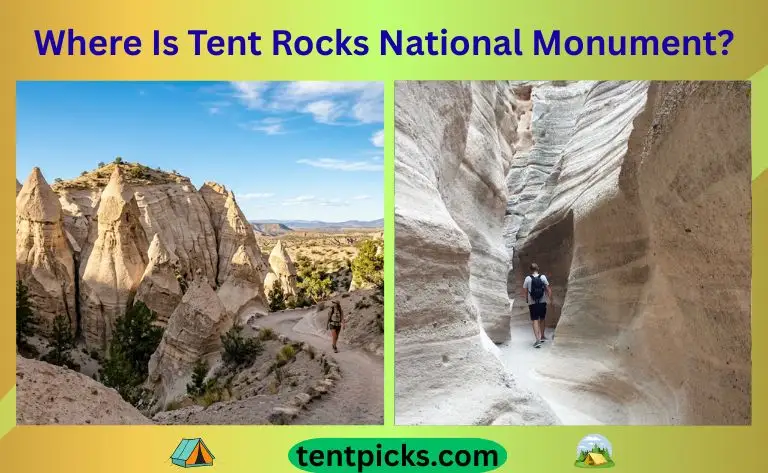
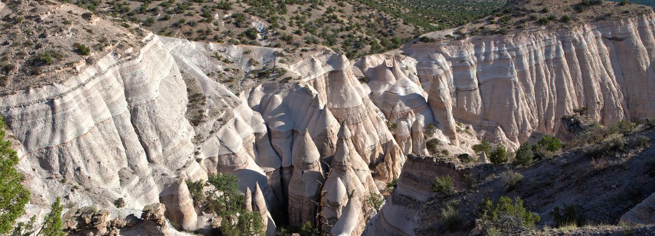
Kasha-Katuwe means white cliffs in the Keresan language. The cone-shaped hoodoos formed as water and wind carved soft layers of volcanic ash, pumice, and tuff from ancient Jemez eruptions. Harder capstones shielded the softer rock below, shaping the famous “tents.”
This is a living cultural landscape. The monument is managed by the Bureau of Land Management in close coordination with the Cochiti Pueblo. The question Where Is Tent Rocks National Monument? is also about context. It is where geology, ecology, and Pueblo stewardship meet. Respect for the land is part of the experience.

Current access status, hours, and permits
Access has been subject to extended temporary closures. As of recent public notices, the monument has remained closed to protect natural and cultural resources and to update management plans. Conditions can change. Check the Bureau of Land Management and Cochiti Pueblo updates before planning your day.
When open, the monument usually operates as a day-use site with set hours and a small per-vehicle fee. Parking is limited, and entry may pause when lots fill. Pets are not allowed on the trails, except for trained service animals. If you are searching for where the Tent Rocks National Monument is, set your GPS, and also confirm if it is open on the day you want to visit.

Best time to visit and weather
Spring and fall bring mild days, clear skies, and good light for photos. Summer heat can be intense, and monsoon storms bring lightning and flash flood risk in slot canyons. Winter can mean icy steps and snow on shaded cliffs.
Start early for cooler temps and easier parking. Bring more water than you think you need, sun protection, and a wind layer. Where Is Tent Rocks National Monument? It is at altitude, and the sun is strong even on cool days.

Trails and what to expect on the ground
Two trails define most visits when open. The Slot Canyon Trail is a moderate hike through a narrow slot, then a steeper climb to a panoramic mesa. Plan for sand, stone steps, and some scrambling. The Cave Loop is easier, with gentle grades and views of cone formations and a small cave-like feature in soft tuff.
Expect uneven footing, tight passages, and drop-offs near the summit. Turn around if water, ice, or crowding make the slot unsafe. When you ask Where Is Tent Rocks National Monument?, also ask how your group handles heat, altitude, and narrow spaces.
Practical tips, safety, and Leave No Trace
Pack at least two liters of water per person on warmer days. Wear closed-toe shoes with a good grip. Bring sunblock, a hat, and snacks.
Carry out all trash. Stay on marked trails to protect fragile soils. Do not climb on the hoodoos or carve rock. Obey all closures and cultural protection signs. Where Is Tent Rocks National Monument? It is where your choices shape the place for the next visitor.
Nearby attractions and respectful alternatives
If Tent Rocks is closed or at capacity, you still have great options nearby.
- Cochiti Lake Recreation Area for picnics, paddling, and birding.
- Bandelier National Monument for cliff dwellings, ladders, and canyon hikes.
- Valles Caldera National Preserve for wide meadows, elk, and volcanic history.
- Ojito Wilderness for hoodoos, fossils, and open desert scenery.
- Plaza Blanca near Abiquiú for white hoodoos and easy access.
These sites offer similar geology or scenery. They also spread out the visitor impact, for travelers searching for Where Is Tent Rocks National Monument?, planning a Plan B makes your day smoother.
First-hand notes and lessons learned
I first hiked the Slot Canyon Trail on a cool October morning. The narrow walls kept the air crisp, and the final mesa view stretched from the Jemez to the Sangres. Starting at sunrise meant I moved through the slot before crowds pinched traffic in the tighter bends.
A few tips from the trail that still hold up:
- Park early to avoid a midday closure of the entrance road.
- Carry a small daypack and keep your hands free for boulders and steps.
- Respect Pueblo lands and posted signs. Photography is a privilege, not a right.
- Watch the sky. If you hear thunder, leave the slot sections and gain high ground if safe.
These simple habits make any visit better. They also answer the real heart of Where Is Tent Rocks National Monument? It is where preparation meets respect.
Frequently Asked Questions: Where Is Tent Rocks National Monument?
Where is Tent Rocks National Monument located?
It is in Sandoval County, New Mexico, between Santa Fe and Albuquerque, near Cochiti Pueblo. The official name is Kasha-Katuwe Tent Rocks National Monument.
Is Tent Rocks open to the public right now?
Access has been subject to extended temporary closures. Check the Bureau of Land Management and Cochiti Pueblo notices before you go.
How far is Tent Rocks from Santa Fe and Albuquerque?
It is about 40 miles from Santa Fe and about 55 miles from Albuquerque by road. Drive times run 45 to 75 minutes, depending on traffic and stops.
Do I need a reservation or permit?
When open, it functions as a day-use area with limited parking and a small fee. Reservations may not be required, but entry can pause when lots are full.
Can I bring my dog to Tent Rocks?
Pets are not allowed on the trails, except for trained service animals. This rule protects wildlife, cultural sites, and visitor safety.
What are the main trails?
The Slot Canyon Trail is a moderate hike with a steep finish to the mesa. The Cave Loop is an easier loop with classic views of the cone formations.
Is Tent Rocks safe for kids and older adults?
Yes, with care. Choose the Cave Loop for an easier path, and avoid the slot during heat, ice, or storms.
Conclusion
You now know exactly where the Tent Rocks National Monument is. It sits between two major New Mexico cities, on sacred Pueblo lands, where wind and water carved storybook cones out of ancient ash. Plan with care, respect closures, and choose a safe day and time.
If the monument is closed, explore nearby gems and return when it reopens. Ready to plan your route and a Plan B? Save this guide, share it with a friend, and subscribe for updates on openings, trail tips, and Southwest road trip ideas.